
Last update:
GoldClaim: Starfall Nuggets takes places in the land called Valaenia. Valaenia is a vast country, spanning 2048 km² (~790 sq. miles) of land and sea, which is divided into 7 regions. These regions are interconnected to each other with over 300 km (~186 miles) of road, where prosperity and hardship are shaped by the land itself. From the fertile plains of the Greenmere Meadows to the iron-rich ridges of the Red Mesa Mountains, prospectors and settlers push ever deeper into a world still only partially claimed.
Trade routes wind through the Crownlands, ports rise along the Serpent’s Crown, and distant outposts cling to the edges of wilderness in places like the Frostspire Wilds and Blackmere Isle. Beneath these landscapes lie the resources that draw fortune seekers from afar — gold, metals, and opportunity — but in Valaenia every claim must be earned, and the land rarely gives up its riches without a fight.
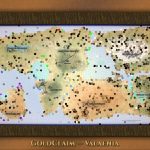
Map of Valaenia
The map design has reached MVP status, meaning that it’s ready to be put on display. This version will be polished a little further, but for further development of the game it’s sufficient to rely on its terrain details.
A redacted and detailed version will be disclosed. The detailed version is hidden and must be explicitly opened to view.
Redacted and detailed version
The lands of Valaenia have been fully mapped. From the fertile plains of the Greenmere Meadows to the rugged mountain chains of the Frostspire Wilds and the Red Mesa Mountains, the landscape of Valaenia plays a defining role in shaping its settlements, trade routes, and natural resources.
The map reveals the major regions and settlements of Valaenia and may contain minor exploration spoilers for players who prefer to discover the world gradually.
In the gallery below, a redacted version is displayed, which is followed by the detailed version.
Note: Spoilers ahead — Do not click the next image unless you want to see the map in full detail.
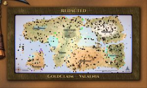

Cartographer’s note: The claim-sites and special POIs remain hidden in the detailed version — these will not be disclosed by us as it’s part of the gameplay.
Regions and settlements of Valaenia
Each region is shaped by its own geological history and natural landscape. From ancient mountain chains to mineral-rich plateaus, fertile plains to tropical lagoons and dense forests to unforgiving snowy mountains, these environments influence settlement patterns, trade routes, and the resources that prospectors seek throughout the country.
Settlements grew naturally along bodies of water, fertile plains and around strategic trade routes. Together they form the backbone of life in Valaenia, supporting prospectors, merchants, settlers, and travelers who move between the country’s diverse landscapes.
In the gallery below detailed images of each region is displayed.
Note: The first image is the starting area, but other images in the slideshow can be considered as spoilers.


At least one settlement can be found in each region of Valaenia. Civilization in Valaenia is concentrated in a network of 12 settlements spread across these regions, excluding frontiers — frontiers in GoldClaim are emergent. These cities, towns, and villages serve as hubs of trade, agriculture, mining, and travel, connecting the more remote parts of the country with its growing industrial centers.
Settlements and POIs are represented with an illustration:


Valaenia consists of the following regions:
- Greenmere Meadows
- Oldstone Highlands
- Crownlands
- Red Mesa Mountains
- Emeral Mantle
- Frostspire Mountains
- Blackmere Isle
Each region has a story of its own, but a single settlement per region will be covered for now. Other settlements have not been fully designed yet and will follow later — this is a living page.
Greenmere Meadows
The Greenmere Meadows form the agricultural heartland of Valaenia. Broad plains of fertile soil stretch across the region, fed by the Silverrun river and sediment deposits carried down from the surrounding highlands. Over centuries, these alluvial layers have created some of the most productive farmland in the country.
Beneath the rich soil lie compact sedimentary layers and occasional gravel beds, hinting at geological activity that once shaped the valley. Today the region supports several settlements and trade routes that connect the interior of Valaenia.
This is where the story begins.
Town: Rivergarden
Rivergarden is a quiet and welcoming settlement nestled along the banks of the Silverrun River, deep within the fertile plains of the Greenmere Meadows. Known for its calm atmosphere and surrounding farmland, the village offers a peaceful starting point for those arriving in Valaenia in search of opportunity.
The Silverrun River, which originates in the mountains of the Crownlands, carries mineral-rich sediments and fresh water across the plains. Over time these deposits have created deep alluvial soils that nourish the vast meadows surrounding Rivergarden. The result is some of the most productive agricultural land in the country.
Large-scale farms dominate the landscape around the settlement. These expansive fields — some covering nearly a square kilometer each — produce enormous quantities of grain, vegetables, and livestock, supplying food to towns and cities throughout Valaenia. The gentle terrain and reliable water supply have made the region ideal for this kind of agricultural development.
Despite its prosperity, Rivergarden remains a modest settlement where farmers, traders, and travelers pass through at an unhurried pace. For many newcomers to Valaenia, it is here — among the quiet fields and winding riverbanks — that their journey begins.
Oldstone Highlands
The Oldstone Highlands are among the oldest geological formations in Valaenia. Weathered ridgelines and exposed bedrock dominate the landscape, revealing layers of ancient stone shaped by millions of years of erosion. Granite outcrops and fractured rock formations create rugged terrain overlooking Lake Silverfall, making the region both dramatic and difficult to traverse.
Despite its harsh landscape, the Oldstone Highlands are known to contain scattered mineral veins embedded within its ancient rock layers, attracting prospectors willing to work in its steep and unforgiving terrain.
City: Gravenport
Gravenport stands on the far western coast of Valaenia, where rugged highlands meet the open sea. Built around a natural harbor, the city grew steadily as ships began to use the port as a gateway for trade with distant shores. Warehouses, cranes, and long piers dominate the waterfront, where cargo vessels and fishing boats move constantly between the docks and the wider ocean.
Unlike the aristocratic atmosphere of the capital in the Crownlands, Gravenport developed with a more independent spirit. Many of its inhabitants are dockworkers, traders, craftsmen, and laborers who prefer the straightforward life of the harbor over the politics of the capital or the rigid structures of industrial centers elsewhere in the country. This has given the city a reputation for being practical, hardworking, and somewhat rough around the edges.
The surrounding Oldstone Highlands are characterized by ancient bedrock and weathered hills, remnants of some of the oldest geological formations in Valaenia. Just inland lies Lake Miner’s Boot, a large freshwater lake whose distinctive shape resembles just that. The lake and its surrounding terrain have long attracted prospectors searching the fractured stone ridges for mineral veins, while the port of Gravenport provides a natural outlet for goods leaving the region.
Today, Gravenport thrives as one of Valaenia’s most important trading hubs. Its prosperity comes not from tourism or politics, but from the steady rhythm of ships arriving and departing — powered by the skilled workforce that keeps the docks moving and the trade flowing
Crownlands
Located near the center of Valaenia, the Crownlands serve as a crossroads between the country’s major regions. The region is particularly known for the Silverrun Springs mountains, from which the Silverrun River emerges and flows deep into the Greenmere Meadows.
Rolling hills and shallow valleys define the terrain, formed through gradual uplift and erosion over long geological periods. The bedrock beneath the Crownlands consists largely of stable sedimentary formations interspersed with older stone ridges. This balanced terrain has made the region ideal for settlement, infrastructure, and the development of key roads linking the surrounding provinces.
City: Highvale
Highvale stands as the political and cultural heart of Valaenia, serving as the capital of the Crownlands and the seat of the kingdom’s governance. Overlooking the sheltered waters south of the Lagoon of Valor, the city grew where inland trade routes met the coast, allowing merchants, diplomats, and travelers to converge at a single strategic point.
The surrounding terrain consists of gently rolling hills and stable sedimentary formations typical of the Crownlands. These foundations made the area ideal for large-scale construction, enabling Highvale to expand into a structured and enduring city. The nearby Silverrun River and coastal access further strengthened its position as a center of administration and commerce.
Highvale is home to many of Valaenia’s aristocratic families and political institutions. Government halls, estates, and administrative buildings dominate its inner districts, while bustling docks and trade houses connect the capital to the wider country. From this city, decisions are made that shape the future of Valaenia, even as prospectors and settlers continue to push outward across its diverse regions in search of fortune.
Red Mesa Mountains
he Red Mesa Mountains rise sharply from the surrounding landscape, their distinctive plateaus and cliffs colored by iron-rich sedimentary rock. Layers of red sandstone and mineral-laden strata give the mountains their characteristic appearance and hint at the geological forces that formed them.
This region is particularly rich in metal deposits. Iron formations, copper traces, and other minerals can be found throughout the mesas and valleys, making the Red Mesa Mountains one of the most resource-intensive regions in Valaenia. Civilization flourished here as iron mining fueled the growth of local industry.
Village: Eredale
Eredale is a resilient frontier village perched along the northern edge of the Red Mesa Mountains, where the desert landscape meets the waters separating the mainland from the Emerald Mantle. What began as a modest outpost for prospectors and engineers gradually evolved into a permanent settlement after the region proved unexpectedly profitable for mining operations.
The Red Mesa Mountains are known for their iron-rich sedimentary formations and mineral-bearing strata, but the harsh desert environment presented a significant challenge: fresh water. Early mining efforts repeatedly suffered from equipment failures when salt water was used in pumps and processing machinery. The solution came through the development of desalination techniques, allowing seawater to be converted into usable fresh water for both mining and daily life.
With a reliable water supply finally secured, Eredale began to grow. The village became a strategic hub for prospectors working the surrounding mesas and mountain ridges, supporting mining camps scattered across the region. Despite its relatively small size, Eredale remains the only permanent settlement within the Red Mesa Mountains, making it an important gateway for those seeking fortune in the mineral-rich frontier.
While the nearby industrial city of Ironhaven dominates large-scale metal production, Eredale offers an alternative path for workers and entrepreneurs who prefer the independence of frontier mining. Trade between the two settlements has become vital, with raw materials, machinery, and labor flowing between them — a relationship that sustains both communities despite their contrasting characters.
Emerald Mantle
The Emerald Mantle is a vast expanse of dense forests, swampy areas and a lake rich in minerals. Beneath its thick vegetation lies a mixture of sedimentary rock layers and ancient volcanic deposits that contribute to the region’s diverse terrain.
Forests spread across rolling hills and wetlands where groundwater and lake systems sustain rich ecosystems. Though much of the land remains untamed, the region’s geological diversity is remarkable. Swamps, winding roads, and sweeping vistas attract adventurers and sightseers alike.
City: Ironhaven
Ironhaven is the industrial heart of Valaenia. Built near a large freshwater lake and within reach of the iron-rich slopes of Mt. Ferrosa (Red Mesa Mountains), the city grew rapidly as mining operations expanded across the region. What began as a modest extraction settlement gradually evolved into a powerful industrial center that supplies machinery, tools, and refined metals to settlements throughout the country.
Tall smokestacks, smelters, and metalworks dominate the skyline, their furnaces running day and night. Rail lines and heavy transport routes carry raw materials from the surrounding mountains into vast foundries, where ore is processed and transformed into the equipment that powers Valaenia’s growing industries. The constant rhythm of hammering steel, steam pressure, and machinery has become the defining sound of the city.
Ironhaven’s economy revolves around manufacturing and engineering. Workshops and fabrication yards produce mining equipment, industrial components, and mechanical parts used throughout Valaenia. Skilled laborers, engineers, and machinists form the backbone of the city’s workforce, giving Ironhaven a reputation for technical ingenuity and relentless productivity.
Despite its heavy industry, the city also serves as a vital trade hub. Merchants, traders, and transport companies move goods between Ironhaven and the surrounding settlements, linking the industrial output of the Red Mesa Mountains with markets across the country. For many operations in Valaenia, the machines that keep their enterprises running were forged in the furnaces of Ironhaven.
Frostspire Wilds
The Frostspire Wilds are defined by towering mountain peaks and cold alpine forests. Formed through powerful tectonic uplift, these mountains expose hard crystalline rock and steep slopes that remain largely untouched by settlement.
Glacial activity once shaped much of the region, carving deep valleys and leaving behind jagged ridgelines and scattered moraine fields. Harsh winters and difficult terrain keep most travelers away, though the exposed bedrock occasionally reveals unusual geological formations.
City: Valcross
Valcross stands at the narrow land bridge between the Crownlands and the Frostspire Wilds, where the cold northern mountains meet the waters of the Serpent’s Crown. Its position at this natural crossing made the settlement inevitable: Every traveler, merchant, and caravan moving between the eastern wilderness and the heart of Valaenia must pass through Valcross.
What began as a fortified waypoint for traders gradually grew into a major city as roads, bridges, and supply routes converged at the crossing. The surrounding terrain consists of hard crystalline bedrock shaped by ancient tectonic uplift, with glacial valleys cutting deep into the landscape. These geological foundations made large construction projects possible, allowing Valcross to expand into a substantial urban center despite the harsh northern climate.
South of the city lies a growing industrial district built along the sheltered shoreline. Here, factories and processing facilities handle materials arriving from the surrounding regions, while ships navigate the narrow waters connecting the inland seas. Though the Frostspire Wilds are known for their severe winters and formidable mountain ranges, the region has long drawn explorers, surveyors, and prospectors intrigued by the geological richness hidden beneath its rugged terrain.
Today, Valcross serves as both gateway and guardian of the north — a city where commerce, industry, and exploration meet at the edge of the wilderness. Beyond its roads and rail lines, the Frostspire Wilds stretch outward into a landscape that remains only partially understood, promising both hardship and opportunity for those willing to venture further.
Blackmere Isle
Blackmere Isle lies off the western coast of Valaenia, separated from the mainland by deep waters and strong currents. The island’s terrain is shaped by volcanic rock and dark basalt formations, giving the land its distinctive appearance.
Cliffs and rocky shores dominate the coastline, while the island’s interior features rugged hills and sparse vegetation. Though remote, Blackmere Isle has long drawn attention for its unusual geology, but especially — REDACTED —
Village: Cinderholm
Cinderholm is a coastal village nestled along the shores of Sunset Lagoon on the western edge of Blackmere Isle. Despite its modest size, the settlement has developed an unusual reputation across Valaenia as a place of quiet retreat. Travelers, adventurers, and retirees alike are drawn to its calm waters, warm climate, and striking coastal scenery.
The island itself is formed largely of ancient volcanic rock and dark basalt formations, remnants of long-dormant geological activity that shaped the terrain of Blackmere Isle. Inland from the village rises the imposing Mt. Mordane, a solitary mountain whose rugged slopes dominate the landscape. Though its geological origins are clearly volcanic, the mountain carries an air of mystery among the inhabitants of Cinderholm.
Locals rarely speak its name aloud when queried how to reach the mountain. Instead, they simply state “No one goes near the Silent Peak”. Whether due to old superstition, unexplained events, or long-forgotten stories passed through generations, most residents prefer to keep their distance from its shadowed slopes.
Fortunately, life in Cinderholm revolves far more around the coast than the mountain. Sunset Lagoon offers calm waters and golden evening skies that have made the village a favored destination for visitors seeking rest and scenery. Small docks, guesthouses, and seaside cafés line the shore, supporting a steady flow of tourists who come to enjoy the island’s peaceful atmosphere.
Though remote compared to the mainland, Cinderholm thrives as a small but lively community — a place where travelers pause to admire the beauty of Blackmere Isle, even while the silent presence of the mountain looms quietly in the distance.
Geography
The landscapes of Valaenia reflect a long and complex geological history. Ancient mountain formation, volcanic activity, glacial movement, and centuries of erosion have shaped the country into a diverse terrain of highlands, valleys, forests, and coastal plains. These forces left behind a patchwork of rock formations and soil types that give each region its distinct character.
Rivers such as the Silverrun carve their way across the land, carrying sediments from the mountains into the plains. Over time these deposits formed the deep soils of the Greenmere Meadows and reshaped the surrounding lowlands. In contrast, regions such as the Oldstone Highlands expose far older layers of weathered bedrock, where time and erosion have revealed the foundations of the land itself.
To the south, the Red Mesa Mountains display striking bands of iron-colored sandstone and uplifted strata, evidence of powerful geological forces that once shaped the region. Further north, the jagged peaks of the Frostspire Wilds show signs of tectonic uplift and ancient glaciation, where ice and stone worked together to carve deep valleys and exposed ridgelines.
The Emerald Mantle presents a different landscape entirely — a dense network of forests, wetlands, and freshwater systems resting above complex underground formations. Meanwhile, Blackmere Isle rises from the sea on volcanic foundations, its dark basalt cliffs and solitary peaks marking the remnants of long-dormant geological activity.
Together, these varied landscapes have influenced where people settled, how roads and trade routes developed, and which regions attracted the attention of explorers and surveyors throughout Valaenia’s history. Even today, the country’s geology continues to shape both the character of its regions and the opportunities that lie hidden within the land.
The Frontier Ahead
Though much of Valaenia is now mapped and settled, the country remains a land shaped by discovery. Roads connect its towns and cities, trade flows through its ports, and farms stretch across the fertile plains — yet vast landscapes still lie beyond the reach of everyday travel.
Mountains rise where few have ventured, forests conceal forgotten paths, and remote coastlines hint at stories not yet fully told. Across the country, explorers, surveyors, and travelers continue to study the land and chart its features, slowly revealing the character of Valaenia one discovery at a time.
For those arriving in Valaenia for the first time, the journey often begins in the quietest of places — a small village, a lonely road, and a distant horizon that invites a closer look.
And as many soon learn, the land of Valaenia always has more to reveal than first meets the eye.